Search: Advanced | Preference

Traveling Boy means the travel adventures of the Traveiling Boitanos
Travel adventures of Wendy Koro Boitano
Travel adventures of Allan Smith Boitano
Travel adventures of Tamara Lelie Boitano
Travel adventures of Jim Friend Boitano
Travel adventures of Deb Roskamp Boitano
Travel adventures of Terry Cassel Boitano
Travel adventures of Joel Polinsky Boitano
Travel adventures of Jeff Fried Boitano
Travel adventures of Herb Chase Boitano
Travel adventures of Ringo Boitano
Travel adventures of Raoul Pascual Boitano
Travel adventures of Timothy Mattox Boitano
Travel adventures of Eric Anderson Boitano
Travel adventures of a Boitano family friend

Colorado ad


About Jim   write me    Feeds provide updated website content        

Glacier Peak I Will Destroy You

Glacier Peak, North Cascades National Park
Glacier Peak money

lacier Peak is ruining my climbing resume. I wish to kick the arse end of it, but its wily resistance has wrecked my passage to its lofty apex three years in a row now. I have climbed many +10,000 foot peaks, almost all of them on my first attempt, but this 10,541 foot holdout is solidifying a certain bitterness within me that will ultimately lead to success, for sure. That's how I look at it anyway; the mountain may have other plans.
Glacier Peak is just one of a number of completely awe-inspiring summits in north central Washington State that lie within the boundaries of the epic North Cascades National Park. The North Cascades range is a climber's paradise, and provides staggering views of truly amazing peaks and assorted mountain wildness. From time to time, locally, here in Seattle, you'll see a license plate holder that declares, "Washington…America's Switzerland." When you drive up into the North Cascades, you see why the people here would make such a claim. Astounding. Epic. Unforgettable.

Now you've probably at least once been in a designated wilderness area before. If you have, you know that they're always in remote locations. Not only is Glacier Peak Wilderness remote, but it is vast, which puts the closest active trailhead over 15 miles from the summit. Ouch. For the climber, this equates to at least 30 miles of hiking roundtrip. Only the fittest of mountaineers can do this trip in two or three days, so most of us are probably looking at three to five days. I, being the accomplished mountain climber that I fancy myself to be, decided I could do it in two to three days, because I am, of course, completely hardcore and fail at nothing. (If you can't remember how that panned out, just read first two sentences of this article one more time.)

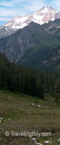
I've always had my eye on Glacier Peak. It just sounds cool. Glacier laden valleys fiercely guarding an ice rimed, wind swept cap, a challenge for all seasons. Heck yes. Before I had moved from the northwest to California, it was one of the few northwest peaks I had desired to climb but hadn't gotten to. When I moved back six years later in 2005, it was pretty much Job #1 on my mountaineering list, so I did a bit of internet research and headed up there. The last successful climb I had seen posted had been from a couple of years previous, but this was only mildly puzzling. I figured that this fact meant good things for me since there were probably very, very few people climbing it year to year, and I like being alone on a mountain. When I got to the ranger station in Darrington, a map displayed prominently on their cork board outside the building declared only bad news. The rangers had painted a red line around a full three quarters of the whole mountain, denoting no access. Much to my surprise, I found out that spring flooding in 2003 had wiped out almost every road approach, many trailheads, and large sections of individual trails. I hadn't heard a thing about it. Over ten inches of rain had fallen in October of that year, and the resulting deluge caused Glacier Peak to shed itself of most of its paved approaches, bridges, trails, and campsites, and in so doing, made itself effectively inaccessible. So bad was the devastation, a ranger informed me that the Forest Service, a full two years later, still had almost a dozen vehicles trapped up in the mountains beyond the washed out bridges and roads. She stated that the only way to retrieve them would be by helicopter, which meant they would probably stay until The Rebuilding, as that recovery option was way too expensive. She also had no guess as to when the infrastructure would be repaired. Looking on the map, I found that the nearest available approach would be a full (35 mile) roundtrip slog from an exotic southeasterly approach. I was not mentally prepared for that, and also didn't have the time on that particular trip. Instead, to console myself, I drove into Canada for the afternoon, and ate like five donuts at a Tim Horton's, which almost fully assuaging my fluttering pangs of disappointment.

wild flowers on Glacier Peak Glacier Peak Wilderness flowers

In 2006, a particularly brutal work regimen kept me postponing the climb until late September. The weather had been remarkable each weekend, so I was greatly anticipating my attempt. When I finally had a free weekend, the weather turned sour the very Friday morning I was to leave. Clouds descended from the heavens, and from then on for the rest of that year the mountain was entombed in snow and ice.

Aha! So here we are in 2007, when my climb would certainly be an inevitable success. In August, I took five days off and planned three for the climb attempt. Leaving from Seattle, it was about a two hour drive to the trailhead, the last ten miles of which was very decent Forest Service dirt road. Thankfully, the last five miles of this road had just opened up from the 2003 flooding event the previous week. As is somehow my custom, I arrived at the North Fork Sauk trailhead in mid-afternoon, around three o'clock. There were about ten cars there. Thankfully, late as I was, as soon as I pulled into my parking space, I saw a couple straddled with huge backpacks that were just heading out toward the trailhead, which made me feel a bit better.
As I stepped outside of my vehicle and attempted to tie up all the loose ends of packing so I could get on the trail, I was assailed by black flies galore, and mosquitoes. I had already mentally prepared for this, as I remember a friend telling of a week long hike in Montana's Glacier Park that had almost driven him to a small nervous breakdown because of the relentless swarms of biting insects that assailed him every moment of every day. I knew the North Cascades would be the same type of environment. Sure enough, there they were, hordes of determined black flies with no other objective in life but to land on you in some exotic spot, dig down under your skin and feast on your blood, willing to risk their lives to accomplish the task. There were no slackers in the bunch, no half-hearted souls … every last one would risk their lives and battle to the very end. Adding to the arm flailing swat fest were the mosquitoes, which specialized in filling the very small vacant niche the black flies couldn't cover. Crafty choosers those mosquitoes … biting you through your clothes on your shoulders and neck, through your socks … I spent just about as much time swatting the whole cast of these sinister fanged creatures away from me as I did with my preparations for gathering up my things and leaving my vehicle.

Finally freed from what was only the very beginning of this torture, I filled out the climbers log and got on the trail. It was about five miles of a hike to Mackinaw Shelter along the North Sauk Fork Trail, and along the way, me and the two hikers I had seen leaving the trailhead on my arrival played a game of leapfrog, over and over again. Conversing on each passing, I found out they were from Fresno, pursuing a northwest vacation, and said they thought they might try for the summit, although they weren't sure. Once when I passed them, I observed the girl eating something from the bushes on the side of the trail. I asked her what she was doing and she showed me what a huckleberry looked like. Somehow, I had never seen one of these before in the wild, but ate plenty throughout the trip. Of course, every time I would stop to do this, the bugs would find me and drive me into deep humility as I responded to them with my Tourettes-inspired verbalizations and ducking and swatting dances.

Arriving at the Mackinaw Shelter, a dirty little woodpile of a mountain shack five miles from the parking lot, the trail took a sinister turn. Vertically. For a number of miles after the shelter I found the steepest trail terrain I'd ever personally hiked. The only thing that I could have compared it to, oddly enough, would be the southern approach to Mt. Baldy in Southern California. Leg shatteringly steep. Even so, I was rewarded with views of some of the best of alpine meadows, fully in bloom, that I can ever remember seeing in the wilds. Somewhere around the third mile of this, it started getting dark, and a couple of headlights came bobbing down the trail. It turned out to be two very stoked twenty-something hikers who had made the summit earlier that day and were determined to get down to the trailhead. They were really cool and so amped up I was sure they would actually make it all the way out that night, even though I knew for certain they had already done some horrible muscle ravaging work to get to the summit and then all the way down to this point, which was still a full eight miles from their final destination. I was encouraged to hear that someone had summitted, which virtually guaranteed my success, I reasoned … If these kids could do it, I would ultimately kick their behinds, if in the final analysis our trips could somehow be compared.

view of Glacier Peak from the south
A view of Glacier Peak from the south

Much of my concern on this trip was to whether or not I needed crampons. I thought about that a lot, both before and during the trip. Crampons are dang heavy, so you mentally weigh very carefully before a trip whether you need them or not. If you bring them and don't need them, it makes you angry to think about having carried them the whole way for nothing. Aggravating. On the other hand, if you encounter a steep field of snow and ice in the last 200 feet to the summit and don't have them, you're risking your life to press on without them. I asked the young fresh fellows whether they had brought any or not, and these dang kids said no, they didn't bring them and hadn't needed them. They said they saw some other climbers using them close to the summit though. (Undoubtedly, all these climbers were 36 years old, I internally reckoned.) At this moment, I could feel the extra weight of the crampons in my backpack slowly sinking my ankles into the soil of the trail I was standing on. I nearly had to adjust my stance to avoid sinking straight to the center of the earth. Aaargh. Anyway, those cool kids were off and I was all the better for having bumped into them, and vastly encouraged about my chances of making the summit. With one of them throwing a determined fist toward the sky, they departed with an enthusiastic, single-word battle cry: "Denny's!"

About the time I hooked up with the Pacific Crest Trail it got completely dark. I adjusted my headlight for maximum output and plodded up the still very steep section of trail for another hour and a half to Red Pass, which exists on the jagged crux of a knife edged ridge, far above the tree line. Once there, the first thing that caught my eye was the carved wooden sign that declared Red Pass off limits to campers. Whoever makes the decisions at the Forest Service concerning these types of things is obviously clinically insane. This guy has never been out of the office in his life. Every time you get to a place you want to camp in a wilderness area, virtually on the verge of physical collapse, there is always just such a sign staring back at you, strategically placed so it can glare back down at you right at the spot where you strike your tent.

Pulling the sign up from the small rock pile it was weakly sticking out of, and placing it face down on the ground in front of me, I surveyed the grand view into the eastern valley that opened up before me. I still couldn't see Glacier Peak itself but even in the starlight could make out an area that appeared to be an area of alpine lakes off its south shoulder, somewhere around the White Chuck Glacier. Then, hastily preparing my tent, I hopped inside, very ready to ingest a giant pile of food.

I had everything. Salty crackers with cream cheese, beef jerky in nugget form, grape Gatorade, and a fancy burrito stuffed with black beans and spices. I feasted away to my heart's content. Now, before this year's climbing trip, in the course of an email discussion about something else with a friend, I mentioned that I was going mountain climbing. She responded that she would pray for a safe trip. I replied in my next email, "As for Glacier Peak, where I am headed Tuesday morning, please pray that a bear will attack me on the way up and that I'll have the fortitude to kill it with my bare hands. Then pray that on the way down, a cougar tries the same thing and meets a similar fate. Hopefully I will have a few claw marks on my face also to assist in the later recounting of the tale." Out there in the wilderness, sitting in my nylon tent, covered in breadcrumbs and food wrappers, hands and face soaked in the lovely scented oils of cream cheese and beef jerky, that sort of sentiment somehow began to fail in me.
I fell asleep thinking about grizzlies and panthers.

A few hours later, my worst fears came to pass. At the same instant, a mountain lion and a brown bear pounced through the thin walls of both sides my tent, intent on gorging themselves on fattened Seattleite. Instead, surprising each other, they both got into a fight and rolled down the ridge together in a furious fightball, not to be seen again. Ok, that part didn't really happen….

The next morning I got going at around 8:00, which is a big change from the usual 3:00 am summit bids I'm used to, having to get up early to avoid the sun melted snow 
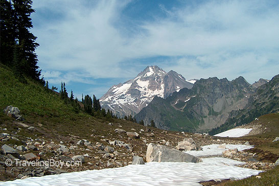
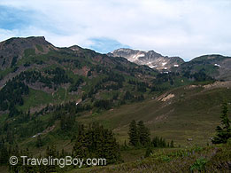
that leads to insane-making "post hole" hiking. Several pictures I found of the mountain online taken during summer months showed a virtually snow free approach on the south shoulder of the mountain. I packed up and viewed my approach choices. The first was to hug the elevation line to the east and end up in the area where I had seen the alpine lakes the night before. This choice, according to what I could see on the map, would have me going completely off trail but at least I could hug the elevation line and not have to endure the body punishment of a lot of elevation gain and descent. The second option was to follow the Pacific Crest Trail (PCT) northward, down to Baekos Creek and hike up the river canyon to the summit. In the midst of this decision making process, there was a problem. I had heard about a forest fire that had developed to the east on the radio the day before, and a thick haze had already filled the air that morning, which meant I couldn't see any great distance in detail to plan my alpine lakes approach. I decided I had better stick to the trail on this particular day because of the visibility. If I hiked up the river canyon, I could always just turn around and bump right back into the PCT if things didn't go right.

Glacier Peak, another view

As soon as I hit the trail, I noticed a lone figure approaching from the valley below. Excellent. When you run into someone in a wilderness area, it's different than just running into someone on the sidewalk. Out in the nether-zones, when a meeting occurs, there before you is a human being who has planned for a long time to be in the middle of nowhere, just like you, and has paid the logistical and physical costs to get there. And you know that each has a predictably burly heart if his willingness has been followed with the action to be standing right there in front of you. With anticipation, I headed down to see who this one might be. It ended up being a guy in his early thirties with a huge backpack, wearing a do-rag on his head which was covered in mosquitoes. He said he was toward the end of a seven day hike, and was dirty, stained, and cut up from having to bushwhack through a still unimproved section of the PCT damaged by the floods. It was a joy to see him, as he had already endured several times the suffering that I would during my whole trip, and his face bore hardened but satisfied testament to the rewards of that type of excursion into the deep.

After our brightening conversation, I glanced one more time at the impressive mosquito congregation that was steadily growing on his head and headed off down the trail, and down, down, down it went. The scenery was gorgeous but I grew concerned very quickly with all the elevation I was losing, knowing I'd only have to make it up again when I got to the intersection with the river valley I'd planned to hook up with. By this time I was well committed to my trail choice, as my opportunity to change course was geographically eliminated right around the time I bumped into the mosquito-headed hiker, cut off from changing course at right about that spot by a rapidly widening White Chuck river to the east, which lay smack dab between me and the mountain. As it was, the trail I was taking was already scarred by the flooding, but it was about to get worse.

Somewhere far into my elevation skydive down the trail, I ran into the intersection of the PCT and the White Chuck river. Although the Forest Service had constructed a big beautiful foot bridge over what was usually a fairly sedate watercourse, it was very clear who had won the battle of the 2003 flood. It was the river. The former footbridge, supported by massive logs, had been tossed with great violence into the waterfall chasm just downstream and was pinched between the rock walls, in shambles. The effect was scary. Scarier yet were the various scraps of wood tossed into the river by previous passers-bys to aid their crossings. I am convinced there are at least three dead hikers downstream of that arrangement. After considering the crossing, it took just a short while to permanently make up my mind. No way. Falling in would have meant a relatively instant death as the water was grey, melting straight off the nearby glaciers, fast running, and flowing into a 40 foot inferno of a waterfall about 10 yards down from my future insertion/dunk point. For my skinny frame this would have equated not to a Man vs. Wild television escape, but rather, severe cold shock followed directly by a wheat-combine thrashing, mass inhalation of water, and a plummeting-down-a-waterfall-but-really-killer-looking Hollywood-villain-style death. That sounded cool on paper, but I wasn't really into it. Instead, I bushwhacked about 100 yards upstream until I found a log straddling the river. It was wedged firmly at a slightly upward angle, and the hop down onto the log from the bank was precarious, but I did it anyway, and shimmied on my butt, inch by inch, across the fifty feet or so of log, with the White Chuck River raging 20 feet below, ready to gobble. Another 100 yard thrashing through the underbrush finally brought me back onto the trail, and it wasn't long after that I was able to hook up with Baekos Creek.

The route looked promising. The creek bed was covered in many big rocks but was also sandy and often virtually flat, so it looked doable. I headed upstream and within 20 minutes was confronted by an insurmountable waterfall. Backtracking a bit, I headed up into the underbrush and made my way around it. As I kept on, I climbed about a mile before the river valley walls steepened harshly. The river walls above the water consisted of crumbling dirt and rock and were completely impassable. Above each wall grew chest high, thick underbrush, a great deal thicker than what I had seen in the forest below. I knew if I tried to make my way through that, it would cost me a precious hour or even two, and I didn't have a knife long enough to hack my way through it all anyway. Maybe if those brilliant engineers at the crampon factory would get their act together, they'd make a crampon that converts into a machete. Sheesh. Worthless. Anyway, taking a good long look at the situation, I knew this route had become hopeless. I don't give up easily, but knew this was certainly the end.

Not discouraged much at all, I took a good long look at the summit, which was right there in front of me, and then turned around and started back. It had been worth it just to get out of the house to hike and climb and experience an alpine environment again. Just as I started hiking down, a military jet shrieked over the mountain at a low elevation, its booming echoes heralding my change of plans. Rather than head down through the rocks and sand again, I decided to bushwhack through the less dense forest that I'd circumvented the waterfall through, except this time, for a change of scenery; I'd hack through it all the way down to the PCT. Going through the forest like that can be rough, but I love the feeling of perhaps being the only person ever to have set foot in a certain place; or if not ever, certainly for the last 50 or 100 years. Off trail and way up a random river valley in the Glacier Peak Wilderness, you can pretty much be sure of that. Part of the fun of that is always keeping an eye out for unusual things, like the bones of a dead prospector from the 1920s, still clutching his pan, or something similar to that. Speaking of which, an interesting feature of being out in the deep wilderness is that out there in the overgrowth, far from the trail, in the middle of the most unvisited spots nature has to offer… you find a lot of balloons. That's right, you heard me right. Balloons. Remember those balloons you set free at your kid's birthday party with all those five year old party attendees wishes tied to them? Or whatever? That wedding you went to? They end up in the wilderness. I found two balloons out there on that stretch of the hike.

Now, here is not the part where you hear me decry the evils of modern balloonery, for all its environmental impact throughout our lovely wild green space. (And by the way, all you greenies out there, they are usually in some very great state of decomposition.) I actually like coming upon balloons out there. Here you are bushwhacking through nature's fury, with all those greens and tans and browns, and out of nowhere, there before you is something that's bright purple or neon pink. Cool. Also, I always make sure to look for a reward note: "Send this note to such and such address and we'll give you $5." I haven't seen one of those yet but it's coming.
Anyway, I finally stumbled my way out of there and got back on the PCT, with that long uphill hike ahead of me. I shimmied my way back over the Death Log, and there just a few steps up the trail was another hiker, who was wearing a very small pack and of all things, one of those 1980's French Foreign Legion caps with the double fabric flaps hanging onto his shoulders. Wow. We exchanged pleasantries, and I noted from his accent that he was Australian. I asked him if he was going to the summit. He said, "No, I'm hiking the trail." I asked, "How much of it?" He replied, "The whole thing." Still confused, thinking he was talking about a noted loop trail that particular section of the trail was a part of, I asked, "You mean the loop trail?" He said, "No, the whole trail. From Mexico to the Canadian border." I was totally amazed. He said he'd been hiking for three and a half months, and had been thinking about doing the trail for eight or nine years, and finally got the time off from work he needed to do it. He was almost done, and expressed relief at the thought, though he didn't look much worse the wear for being on the trail for almost four months. It was a total privilege to have met him.

It reminded me of when my buddy Mylon and I were in Southern California climbing a peak called San Gorgonio a number of years ago. We ran into an older female forest ranger, somewhere around her sixties, who went by the name of Teddy. We talked to her for quite awhile as we were setting up camp, and she was really nice and helpful and fun to talk to. The next day, on our ascent, we ran into a couple of other rangers and somehow communicated to them that we had run into this Teddy the day before.

One of the rangers said, "Oh… I'll bet she didn't mention it, did she?"
Of course we had to ask, "Mention what?"

"That she was the first woman to hike the entire Pacific Crest Trail solo, she's like a legend." He went on to explain that she also lived in a cabin year-round in some nearby part of those woods.

On our way back down the mountain, I saw her working on a hilltop near our campsite so I paused to talk with her again. I told her that some other rangers had told us about her secret, and she quietly, sheepishly admitted that it was the truth. I marveled at this and asked her how old she was. She was nice about it, but kept that to herself also.

The hike back up the PCT to my tent was quite a grind, and by the time I reached camp, I was pretty dang tired, realizing I'd already been hiking for almost eight hours. When I arrived I was relieved to see that no marmot or even bigger animal had chewed through my tent to get to the remainder of my food inside, and I sat down on a rock overlooking the valley I had just hiked through, hoping to rest a bit, and also hoping that the severity of the ridgeline would concentrate enough wind to keep at least the mosquitoes at bay. I was wrong. So horribly, horribly wrong. There was indeed a breeze that would have kept any city bugs away, but these were wilderness mosquitoes, and I was probably only the second hiker they'd ever seen in their lives, and there was no do-rag to separate them from my lovely, blood rich scalp. Looking behind me, I could see tens of mosquitoes fighting furiously to cross over into my wind shadow and wildcat their mining drills into my rich oil fields of Dutch blood.

I couldn't even sit there for a minute in peace, so that did it. I was out of there. I wasn't going to sit in my tent until it got dark, and I couldn't remain outside, so I decided to at least get hiking, and laboriously packed up my stuff. Finally ready to roll with a full pack on my shoulders, I took one more look at the valley I'd just hiked from and noted specifically that the early morning smoke haze that had altered my course plans had already blown through. Alas, it's often these sort of simple choices based on unknowns of temporary circumstances that can change destinies. I turned to leave, thinking about what could have been. Lastly, propping that "no camping" sign back up into its rocky base, I headed off down the trail, with the bulk of Glacier Peak wilderness disappearing behind me. (I think I remember doing that with the sign anyway. If not, hopefully someone cut it up and used it as firewood.) Looking down the grade of the trail, I was really thankful that it had been dark when I had climbed it the night before, because it would have been really discouraging to have seen the angle and length of it during the daytime. That was a true blessing in disguise. The trail was beautiful, with lots of flowers and tall grass and multitudes of large marmots communicating their warning calls to each other, making great haste to bind out of my path when I rounded a corner without their knowing of it.

Somewhere around the area I had run into the two young hikers the day before, I came across another seriously pack-laden hiker. He was headed to White Pass, wherever that was, and was wondering where he could find some water. I told him there was water everywhere. That it was falling from the sky, man. That we were submerged in it. My eyes got wilder and I started to do this Dennis Hopper/Charles Manson hopping dance, flailing my arms in the air, singing about how there was water right there inside him if he'd only wish to see it for himself, man. He just stood there looking at me.

Just kidding. I told him where he could find some water, and off we went. After that encounter, hours passed with much suffering of the leg bones, on the very steepest parts of the trail. I decided when I got to Mackinaw Shelter I would decide whether to press on or not, it would be a full three more hours of hiking after that to get to the trailhead. When I got there, it was effectively dark, and I felt I had no choice. There would be no staying the night at that very boring locale with only three hours of hiking to go. I was destined for greater things: A Big Gulp of Dr. Pepper thick with ice, and a vanilla milkshake at Denny's with some pancakes, laden with butter and syrup.

The last three hours of drudgery, hiking in darkness only broken by my dim headlamp, would be filled with mind games to distract myself from the many forms of suffering experienced on this voluntary death march. After having already been hiking since around 8:00 am, it was necessary. For example, I would count steps. One hundred steps would kill one minute. If I counted a thousand steps, that would kill ten minutes. I also stopped every twenty minutes to eat and drink, which was by that time completely necessary, as the only thing that was keeping my body going was constant food source replenishment. On and on it went.

I finally broke out of there at 11:15 pm. In all, I had hiked for 13 hours that day, a distance of 17 miles, with mucho elevation gain and loss. Combined with the previous day's 10 miles, I hiked for a total 27 miles during the two day trip. Summit not included.

On the way home, I stopped at a 7-11 and got my Big Gulp. Denny's was not on the menu after all however, as I just wanted to go home, and rest my sore arse.

fungus on finger
The deadly fungus.

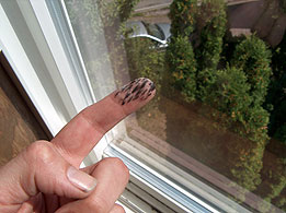
The next day was passed experiencing the life of a cripple. Every time I got up from the couch, I had to move gingerly for two full minutes before my legs would work correctly. A look in the mirror offered a face rimmed with around 25 mosquito and black fly bites. Including other body parts, I counted around 70 bites all together. I also picked up some sort of odd alpine birthed fungus on my left index finger, which stuck around for some time. The next day offered much of the same hobbling and itching, until eventually all things normalized.

I will destroy you, Glacier Peak. All of these sufferings over the last three years will equate to nothing but success at the apex of your lofty, ice and rock encrusted crown. You will feel the bottom of my feet grinding down on the top of your head, and I will be exalted as I stand there, and you will be brought low. Returning home from my conquest, I will write your name on my ice axe with a black Sharpie, right next to all the other victims. Then I will ignore you, my noble boot not setting foot on your soils for the rest of my God-given life, unless one of my prodigious offspring would like to vanquish you just as I have, with my Napoleonic tutelage guiding their every step, until you are, once again, mounted like a lowly, load bearing donkey…

Next year, Glacier Peak, next year.


Jeem!

Found ur Glacier trek (I will Destroy You Glacier Peak) to be serious kick ass. To be honest, I’m such a lightweight, I’ve never been more than a day tripper. When u really get out there on one of those long solo treks, and the water runs short … can u drink from local streams? I’ve heard that pollution is so bad that even places untouched by man are now off-limits.

VitoZee


Howdy VitoZee,

Great to hear from you and thanks for the complement and question. That is a seriously cool name, by the way: VitoZee. Just from the phonetics of it, I get the impression that you might be a very friendly and mild-mannered hitman working out of North Jersey. Really cool.

As for your drinking water from streams question, there are a lot of answers for it. The simple answer is that, no, you can almost never implicitly trust stream water sources, unless they are flowing straight out of the ground (via an aquafer or spring) bubbling up right there in front of you. That's your best bet, but you rarely see that in the wild unless you're looking for it, and even so, I have actually gotten sick from drinking spring water straight from the source at Panther Springs on Mount Shasta. You never know what you're going to get drinking untreated water from the wilds.

Most of the time the pollution you'll be dealing with out in the wilderness is not man-made, it usually comes from bacteria and parasites that inhabit the bodies of wilderness animals. For example, on this Glacier Peak trip, I drank from a stream I was confident was trustworthy. In the immediate vicinity were living quite a few marmots. A number of days after I got home I fell ill, and had to wonder if I hadn't picked up something from the water I drank, as there was not much of any other explanation for my symptoms. I knew a trip to the doctor would probably result in them sending me back home with a plastic cup that was required to be filled with my own poo, which would need to be delivered back to the lab steaming hot so they could figure out exactly what kind of bacteria or parasite they were dealing with. (Not a joke, remember Panther Springs?) After this diagnosis, I would then have to go back to the doctor and get a prescription, but by then, my body would have probably fought off the tiny invaders completely on its own. Not worth the trouble, and all of this would certainly = Jim minus $280. So I suffered it out, and whatever happened to be bothering me left my system in about 7 days or so. Yuck. No fun.

Anyway, I don't recommend drinking straight from the streams of the wild, but in a pinch, I do it everytime, unless I see a bear or a moose straight upstream from me pooping in the river, which has only happened about ten times. (Or zero times.) Anyway, sometimes I get sick, sometimes I don't. If I'm exhausted and thirsty, to heck with it, I'm drinking it.

All this notwithstanding, or withstanding, or notwithoutstanding, whatever, they just recently invented the coolest thing in the world though, so you might want to check it out. Previously, for treating your water in the wild, you'd always have to put a pellet of iodine or a congregate of other evil ingredients into your jug of stream water and let it sit there for an hour before you drink it while the chemical cocktail thoroughly treats your water. That is ridonkulous because when you're hiking and thirsty, you aren't going to wait a full hour for that pill to dissolve and work properly, you are going to guzzle. Anyway, they just invented this magic wand of sorts that you can find at any decent backpacking or outdoors store. You turn it on and dip it in your stream filled water jug, and the ultraviolet light it produces irradiates everything to death on the spot, after about 30 seconds or so. Kind of like my pinky finger, which I keep forgetting to treat my stream water with, because I'm always so dang thirsty.

Jim
Extreme Travel Editor


Name: Required
E-mail: Required
City: Required
Feedback:
 

Jim decides to do Victoria on a whim.


© TravelingBoy.com. All Rights Reserved. 2015.
This site is designed and maintained by WYNK Marketing. Send all technical issues to: support@wynkmarketing.com

Glacier Peak Tips

1. Plan to suffer.
The steep gradients are going to get you good. All the approach trails include very steep stretches. Once you get to where you can reasonably climb the mountain, you still have a long ways to go and the going up to the actual summit will be steep as well. If you ever stop, you will be hounded by ravenous mosquitoes and black flies. They will be all over you between 30 and 60 seconds after you stop, and you will be swatting constantly and walking around to try to get them off you. They will get you. They will wear you down.

2. Plan on being there long enough to summit.
All the approaches are very long. If you're in your early to late twenties and you are totally hardcore, you can probably hike 30 miles in two days. If you are in good shape but not really great shape, better to shoot for three to five days of climbing. Most entries by climbers at the North Fork Sauk trailhead register declared 3-5 day trips, which is reasonable. I hiked 27 miles in two days in steep terrain, and it was doable but punishing. Even then, I got within about a mile and half of the summit, but didn't make it to the top. Had I actually made it to the summit, I would have had to take a third day to get my sore body down, for sure.

3. Choose your summit route carefully.
You're almost better off to choose that route when you get up there and see what's in front of you, rather than predispose yourself to what might look good on the map but would in reality be a difficult approach.

4. Save weight.
When I climbed (in August 2007) there was a lot of water along the trails, a lot of it everywhere I went. Rivers, streams, alpine lakes. Not carrying a full gallon of water or Gatorade up there will be a good thing due to the steep approaches. A bivy sack would be fine if you're thinking about that. Something to zip up in to avoid the bugs is necessary.

Friendly Planet Travel

Lovin Life After 50

Big Sur ad

Tara Tours ad

Alaska Cruises & Vacations ad

Cruise One ad

Visit Norway ad

MySwitzerland.com

Sitka, Alaska ad

Montreal tourism site

Visit Berlin ad

official website of the Netherlands

Cruise Copenhagen ad

Sun Valley ad

Philippine Department of Tourism portal

Quebec City tourism ad

AlaskaFerry ad

Zurich official website

Zuiderzee Museum ad

Like-a-Local.com