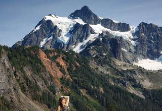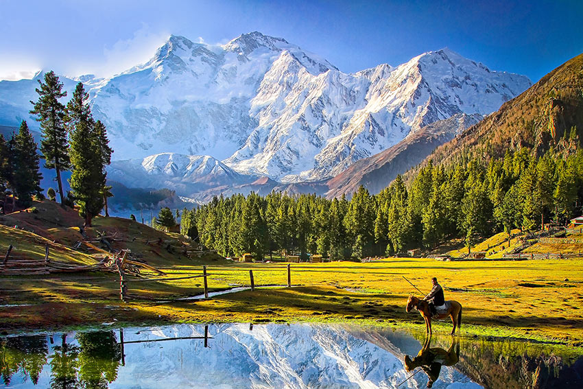
A quick glance at the photo above and you would think that it’s a valley scene in the Swiss Alps. It’s an alpine scene alright — at Fairy Meadows, Gilgit-Baltistan in northern Pakistan, with the snow-shrouded Nanga Parbat, the 9th highest mountain in the world, in the background. Landscapes like this have led Lonely Planet to label Pakistan as “on the brink of being tourism’s ‘next big thing’ for more years than we care to remember.”
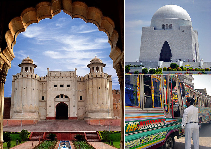
We’ve traveled to Pakistan a number of times before as part of our work with a non-profit organization. Most of these visits were to its major cities — Karachi, Lahore, Rawalpindi and the capital city of Islamabad. Those visits and our friendships with Pakistani colleagues have allowed us to appreciate the country, its culture and its people over the years.
Peshawar
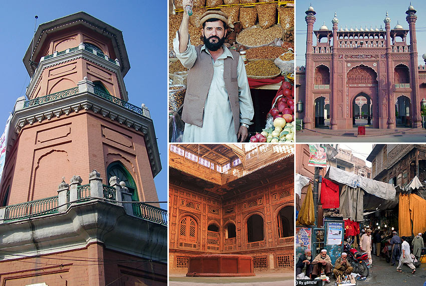
The most interesting city that Leo had a chance to explore, however, was Peshawar in the Northwest Frontier Province (now the Khyber Pakhtunkhwa). The first time he flew into Peshawar it was like entering a city straight out of the Middle Ages. The narrow streets, centuries-old bazaars, walled forts and old architectural designs on wood and brick houses quickly endeared Leo in a strange way to the frontier city and its remarkable people. More than 2,500 years old, Peshawar is located on the strategic crossroads between Central and South Asia — a fact not lost on dozens of invading armies over the centuries. Consequently the city would endure incursions from Persians, Greeks, Bactrians, Turks, Mughals, Afghans, Marathas, Sikhs and the British.
The Khyber Pass
Peshawar is less than 60 kilometers from the border with Afghanistan and lies at the foot of historic Khyber Pass. This famous mountain pass connects the city of Kabul in Afghanistan to Peshawar and runs along a range of arid, broken hills that is part of the Spin Ghar Range. It also happens to be the best route for armies invading South Asia from Central Asia and vice versa ensuring its place as one of the most contested pieces of real estate in history. So heavily fought over is this strategic gateway that a British soldier once said that “every stone in the Khyber is soaked in blood.”
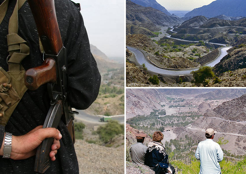
Leo joined a group tour of the Khyber Pass in 2000, a year before 9-11. Starting from Jamrud just outside Peshawar, they drove along the whole length of the pass all the way to the Afghan border and up a bare, rocky summit from where the first village inside Afghanistan was clearly visible. Their escort were two members of the modern-day Khyber Rifles, which was hardly reassuring when a large majority of the native Pashtun tribesmen they met cradled Kalashnikov assault rifles. (The native Pashtuns here are practically the same people group as those in Afghanistan.) Even before the subsequent war in Afghanistan this area was already considered a fairly wild region where banditry, drug trafficking and tribal warfare were common.
While Pashtun tribesmen are known as wheelers and dealers and have a reputation as fierce warriors — having fought ancient invaders, Turks, Mughals, the British and the Soviets — we were surprised to discover that they are genuinely hospitable. A Pashtun family will not have second thoughts about slaughtering their last remaining lamb to feed a guest. A group of Afghan Pashtun villagers in 2013 hid and protected an American SEAL from the Taliban and said they would do it again despite death threats from the extremist group and the disappointments and troubles that have hounded the NATO military campaign in the country. It’s just who they are as a people. Leo experienced this hospitality personally when the owner of a snack shop, upon learning he was a first-time visitor in the region, politely refused his payment.
Northern Pakistan
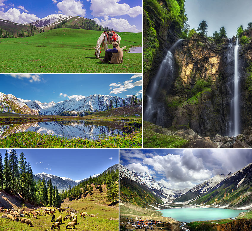
While much of the Khyber Pakhtunkhwa around Peshawar and south of it are mainly semi-arid with historical sites as the main attractions, the regions to the north and northeast are marked by a breathtaking shift in scenery. Just north of Peshawar and still inside the Khyber Pakhtunkhwa (KPK) are the Swat, Kaghan, Kumrat and Chitral Valleys. This region is home to snow-capped peaks, rugged hills, lush green landscapes, rich farmlands and rivers stocked thickly with trout. There are also a number of Buddhist archaeological sites from the Gandhara civilization as well as Hindu archaeological sites.
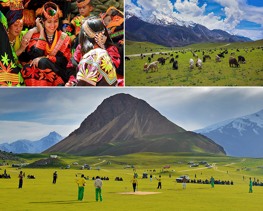
Chitral is at the northernmost fringes of the KPK and is no less stunning compared to its southern neighbors. And it’s not just nature that may be admired here. Chitral is home to the pagan Kalash tribe (said to be descendants of Greeks exiled here by the Persians before Alexander the Great’s time) and also contains several historical fortresses and towers.
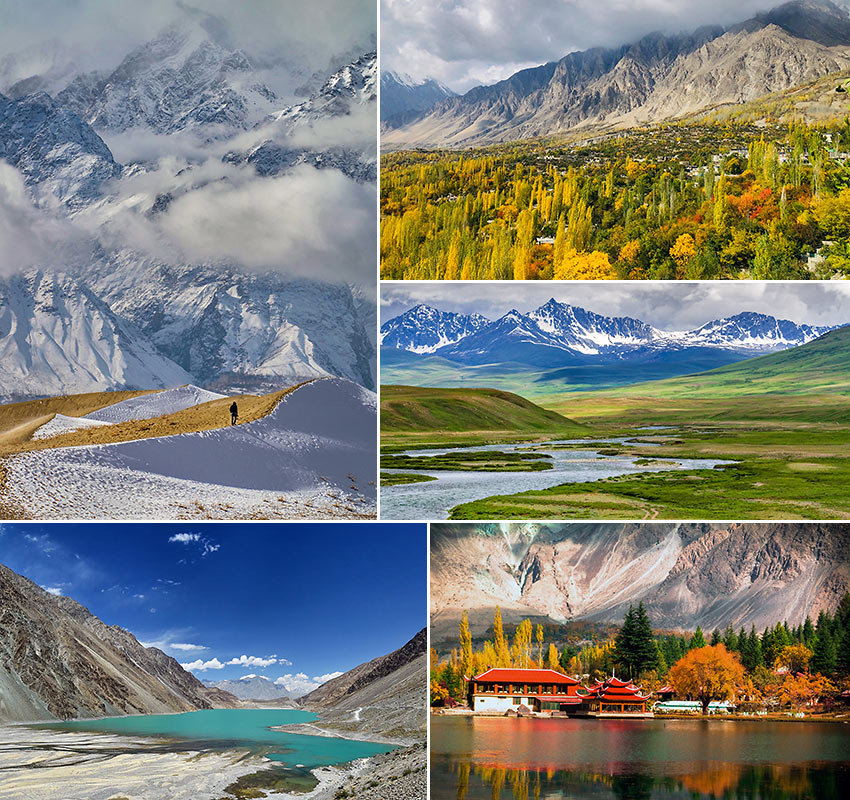
East of Chitral and at the extreme northern end of Pakistan is Gilgit-Baltistan, possibly the most beautiful region in the country. It is home to the Karakoram Mountains and the Hindu Kush, including some of the world’s tallest peaks such as K2 (the second highest mountain in the world) and Nanga Parbat. The Baltoro Glaciers and two others in Gilgit-Baltistan are among the world’s longest outside the Polar Regions. Some of the most interesting and gorgeous nature sites in the South Asian subcontinent, and indeed in the planet, may be found here:
- The Katpana Desert or Biama Nakpo, also known as the Cold Desert, is a unique arid landscape in the highlands near Skardu. Because it is located at a high altitude, the sand dunes here are sometimes covered in snow.
- The Deosai Plains, situated at 4,000 meters above sea level in northern Gilgit-Baltistan, are the world’s second highest plateau.
- The Hunza Valley, a scenic region surrounded by towering peaks lies to the extreme northern end of Gilgit-Baltistan and borders China to the northeast.
- Skardu, the capital of Gilgit-Baltistan, is located at the confluence of the Indus and Shigar Rivers. Normally used as a base for touring the towering Karakoram Mountains, it is also home to Lower Kachura Lake, also known as Shangrila Lake, and stunning Satpara Lake.
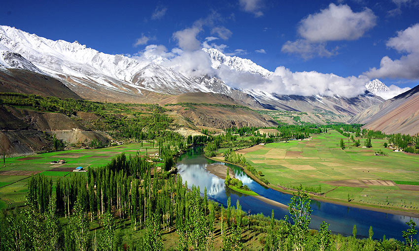
- The Phander Valley is a beautiful valley in the Ghizer district of Gilgit-Baltistan. It is situated on the road to Chitral to the west.
Pakistan is still relatively unknown as a tourist destination even though one can easily appreciate its potential just by looking at the photos here. Armed conflict in nearby Afghanistan and the resulting spillover into the KPK as well as the continued presence of religious extremists have unfortunately gotten parts of Pakistan into Forbe’s list of most dangerous places to travel in 2020.
The Taliban took control of some parts of northern Pakistan more than 10 years ago — including the Swat Valley — but the Pakistani Army had re-occupied these areas and these places are now peaceful and getting their share of tourists (tourism has actually increased by 300%). Peshawar and most of the KPK including Swat and Chitral are relatively safe according to many travelers; Gilgit-Baltistan is said to be the safest in the country. The U.S. State Department, however, while acknowledging the improving security situation due to the Pakistani Army’s efforts since 2014, discourages travel to Pakistan at this time due to Covid-19 and the continued threat of terrorism, even singling out the KPK and other regions.
We hope however, that peace and order in these regions will continue to improve — pending the end of this pandemic — and that Northern Pakistan and its people will be appreciated for their stunning beauty.