When I told people about my plans for a summer camping trip a few years back, the response was almost invariably, “Why?” It wasn’t an unfair question to ask, as my camping trip was a solo journey that took me deep into the Arctic. Beginning in Canada’s Yukon Territory, or “Above 60” as it’s known to the locals (the Territory begins as 60 degrees latitude), I traveled about 800 miles further north on the globe, to the very shores of the Arctic Ocean, by way of seven plane rides, and just over 1000 miles by car – 450 of those miles on a gravel road known as The Dempster Highway.
I’m afraid I fall short in supplying a satisfactory rationale to anyone posing the question of why I would choose to spend precious vacation days alone in the Arctic. I can speak more clearly to the inspiration, which came from an article in the Travel section of the Los Angeles Times four summers prior to my trip. The article chronicled the reporter’s trip to the Arctic Circle, and his drive on The Dempster Highway. I was gripped by the thought of the vast expanse of pure, unspoiled nature the reporter described. The majority of his trip was in the Yukon, a Canadian province as large as California and Oregon combined, yet home to only 30,000 people. What’s more, a full two-thirds of them live in the capitol, Whitehorse. The other 10,000 are mostly indigenous people from the Gwich’in and the Inuit tribes of Northern Canada.
Eskimos (if you’ll pardon the slang)
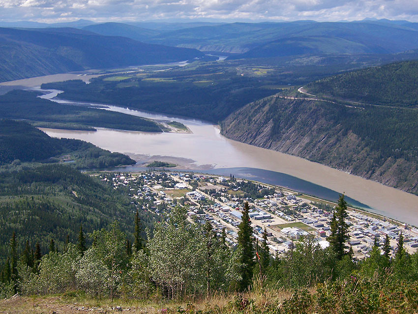
10,000 or so Native North Americans and other sturdy Canadians spread out over a vast expanse of sub-arctic tundra and permafrost. Many still travel by dog sled during their nine-month winters where the Aurora Borealis swirls and twirls, electrifying the permanent night. During their brief two-month summers, when the sun barely dips below the horizon, they gather berries and fill their smokehouses with Arctic fish like Char and Grayling. And Whale.
The world is different there than the world I know. Completely. It is considered one of the most remote places left on this planet, yet still accessible by car. Perhaps that was part of my motivation – the ultimate road trip – to literally drive to the top of the planet and set foot in the Arctic Ocean. To experience being in a part of the world where there are more Grizzly Bears than people. To have a meal of Muk-Tuk and Bannock, Musk Ox burger and Caribou soup in the arctic oil-town of Inuvik. To tee-off on a golf course in the old Klondike gold rush town of Dawson City at midnight while the sun still hangs high overhead…
Perhaps it was just the adventure that drew me there – that beautiful unknown that lurks around every twist and turn of the gravel roads. Whatever the case, the seven plane tickets were purchased, the SUV was rented, the campsites were reserved.
All that was left was the going.
Whitehorse
Friday was a long day. It actually began Thursday night at a bar in Manhattan Beach, in the South Bay section of Los Angeles, where I met up with some friends for some beach volleyball. After three hours of friendly competition and a quick night swim in the Pacific, we replenished ourselves with fried food and pitcher after pitcher after pitcher of beer, as we talked and laughed and toasted birthdays and planned scuba trips and decided upon teams for upcoming volleyball tournaments. It was the second time in three days I found myself biking home at midnight, shorts and tank top still wet, sand stuck to my skin, and a belly full of beer. I dizzily pedaled alongside my buddy Glenn, doing our best to stay on the bike path and avoiding crashing into each other, like that time we were biking through the jungles of Costa Rica – but that’s another story…
Once home I still had hours of work ahead of me, including getting a lengthy list of video and computer equipment, camping gear, clothes, and other items into nothing more than a duffle bag, backpack, and camera bag. Somehow, in spite of my beer-soaked brain, I managed to do exactly that, and was in bed by three in the morning.
I somehow managed to make it to the airport on time the next morning, and a few hours later I cleared customs in Vancouver, British Columbia. My second flight was delayed by an hour, as there weren’t enough people to fill the “big” plane. They swapped it out with a slightly smaller, more “practical” model. Once airborne heading northward, the bustling metropolis of Vancouver and all vestiges of big-city life quickly changed to remote, rugged, and stunning countryside. A coastline carved by meandering rivers and lakes eventually gave way to snow-covered mountain ranges, which gave way to vast expanses of trees, rolling hills, and deep blue glacial lakes. We landed soon thereafter in a small town situated alongside the Yukon River, plopped down in the middle of what seemed to be endless wilderness.
I found the town of Whitehorse bigger than I expected. During the shuttle ride from the airport to my hotel, I saw many familiar stores and restaurants, as well as those unique to the area. Once checked-in to my room at the High Country Inn, I hit the streets on foot – my favorite activity in any new city. As the capital, Whitehorse is the only significant population center in the whole of the Yukon, with about 20,000 residents. Oddly, most of them seemed to be teens and young adults, roving the streets in small, harmless groups, hanging out on corners where the faint smell of weed hung in the air. I listened as a sidewalk banjo player taught a young guitar player a new riff.
I was looking for a place for dinner, but it was after 9:00pm and everyplace I found was closed for the night. In fact, the town was pretty much closed up tight. Knowing that I’d be back in Whitehorse the following Friday, I decided to head back to my hotel, stopping first at the local 20-Hour Mart for some supplies (closed from 2:00am to 6:00am). I was travel-weary, and walking through this foreign city at night with the sun still high in the sky was disorienting and quite surreal, to say the least. It was hard to believe it was 10:00pm.
I made it back to the hotel and had dinner out on the deck, where they keep the barbeque fired-up until 11:00. After dinner, back in my room, I watched the sun set behind the mountains at midnight. Then a funny thing happened – after the sun went down, the light seemed to “freeze” in time. A perpetual dusk blanketed the landscape. A wedge of blue sky cast a soft light over the town, keeping true night at bay.
I ended the evening by taking advantage of the Jacuzzi tub I was surprised to find in my room. As I contemplated the day it occurred to me that, as far away as this place felt, this was where the road just began.
The Klondike Highway
I got a late start on Saturday. A very late start. I didn’t roll out of Whitehorse until 2:30. During breakfast, I got involved in a conversation with my waitress and a fellow traveler. He was a sixty-something retired firefighter who spent thirty years on the job in Los Angeles. Now a resident of Costa Mesa, California, he was up here to go sheep hunting by horseback for eight days. He had a few stories to share, and I was all too happy to listen. I then checked out of my hotel and grabbed the shuttle to the car rental office. My driver, Savannah, who looked too young to drive anything with more than three wheels, upon finding out about my trip up to the Arctic, told me that five people died driving The Dempster Highway just last week. I asked if it was due to hungry bears or human error. It was the latter – speeding around a gravelly turn.
The five young women who worked at Norcon Car Rentals (apparently, the Hooters of Northern Canadian car rental agencies) were happy to tell me all about Dawson, the next stop on my trip, including tales of the Sour-Toe Cocktail. More on that later. The girls were happy to participate in my video-documentary of the trip, and Jenny insisted that I go talk with her uncle. She told me that her Uncle Joey, proprietor of the local fruit stand, was a mustachioed, mulleted midget, and that he loved to talk. She had me at mustachioed. This was all too good to be true. Next stop – fruit stand. I found Joey – he was as described and therefore easy to spot. While not a true little person, he sure was a tiny lil’ guy. And he sure did like to talk. Tales of giant grayling pulled from the Tachun Creek Bridge with nothing more than a piece of bacon and a shoelace. Stories of baby eagles ready to make their first leap from a nearby nest (he demonstrated for me, complete with wildly flapping arms). Stories of fifty-pound trout caught at the lake where he and niece Jenny, and his wife and daughter were going fishing in two weeks. I swear he said it was a shame I’d be home by then, otherwise I could join them. I wanted to hug this little man, but opted instead to purchase two white nectarines and a bag of dried mango.
I made one last stop for some sandwiches and snacks, as well as a cooler and ice, and plenty of water and Gatorade to fill it, before finally punching in Dawson City on my GPS (not sure why I did this, as there was only one road). I headed North on the Alaska Highway and twenty minutes later I rolled up on the Klondike Highway, my home for the next 333 miles.
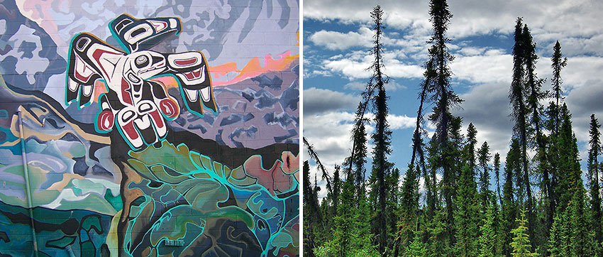
At first, the scenery was not much different than what you may find driving through Oregon, but that changed quickly. Following the Yukon River Valley, I was never out of sight of a river or lake or some small body of water for more than a few minutes. Hypnotic, deep blue pockets of water abounded, some no bigger than swimming holes, some large enough to fill the landscape. Meandering creeks and churning rivers snaked their way alongside the road. Fireweed, a tall plant with bright purple blossoms, lined both sides of the highway, as did marauding bands of steroid-using Ravens. Even more spectacular were the trees – large, open forests of stunted, skinny Spruce, Birch, and Aspen stretching on to the horizon. What made them so unusual, however, is that as the permafrost beneath them melts and shifts and refreezes year after year, the trees begin to lean in all directions and angles. Pockets of these trees covered both sides of the highway for most of my trip, like groups of stumbling drunkards, leaning on each other as they wobbled their way home.
The drive was long, made longer by frequent video and picture stops. In the course of the entire drive I passed no more than a few dozen cars, and four small villages – Braeburn, Carmacks, Pelly, and Stewart’s Crossing. No Denny’s or Wendy’s drive-through at the next exit for a quick bite and restroom break. No Motel 6 if you get tired. No cars or trucks to pass along the way – a surreal and beautiful experience.
I made it to Dawson around 10:30pm, where my campsite was waiting for me. I pitched my tent on a patch of small stones, beneath the balmy evening sun. A cool breeze was blowing in from the North, along with dark and threatening clouds. I had heard talk of thunderstorms later in the evening. I choose to leave the fly off my tent, and fell asleep under the twilight sky, listening to the rattle of wind-swept trees.
The Gathering
Despite the chill in the air and the stones beneath my sleeping pad and the constant light, I slept well. I spent sometime around the campsite Saturday morning, before making my way to the riverfront, a few, short blocks away. Little has changed here since Dawson’s glory-days – during the Klondike Gold Rush, some 115 years ago. I walked along dirt streets, avoiding mud holes that formed near plank-board sidewalks. The wood buildings, many still standing and in use since the gold rush, lean and tilt, just as the sidewalks, just as the trees, just as about anything that attempts to settle down on the ever-shifting permafrost.
I had originally planned to drive to Alaska on this day, but I found out through some locals and tourists that the road was particularly rough along The Top of the World Highway, and the roundtrip drive to Chicken, Alaska would be at least five hours. Seeing as how I have at least sixteen hours of rough driving ahead over the next two days, I opted instead to attend the Moosehide Gathering. This event, sponsored by the tribes local to Dawson (the Han Nation), but open to all of their neighbors, is held every two years on the last weekend in July. It takes place three kilometers upriver, on the sacred healing grounds of the Tr’ondëk Hwëch’in, or “River People.” Small boats took groups of 4 to 6 people at a time, mostly the local native population, but a few tourists as well.
I arrived at the Gathering held on grassy bluff overlooking the river. There were tents and teepees, wood cabins and a Potlatch house spread around the site. A few hundred people gathered, many in ornate and traditional clothes, listening to speeches given by anyone wishing to give thanks. A steady beat of a traditional drum accompanied their offerings. I was just in time for some prayers and the closing feast. Many kinds of local and traditional food were there for all, and I tried a little bit of everything, including baked salmon eggs, moose, and an amazingly rich and sweet treat called a Nanaimo Bar.
After spending some time wandering the grounds, taking pictures, talking to the locals, watching a man build a canoe from a tree, and enjoying the scenery, I hopped a boat back to Dawson. I wandered the dusty streets, shooting video of this town that seemed to be all but forgotten, frozen in blocks of time and ice for the past 100 years, and only recently thawed. I stopped in a few saloons and traded tales of my journey with the locals, who are some of the friendliest folk I’ve ever met. Everyone has a story, and has time to hear yours.
Then I wandered into the saloon at the Downtown Hotel.
The Sour Toe Cocktail (as promised)
I started at the bar with a local beer and the good fortune of finding a Red Sox game on the television. However, I couldn’t help but noticing, sitting at a back table in the saloon’s smoky darkness was the self-titled Belligerent Captain Kate, purveyor of the Sour Toe Cocktail. I took my beer and cautiously approached. A large wooden box sat on the table in front of her, in which was kept not one, but two severed, pickled, human toes. As the story goes, the original owner of the bar found a severed toe beneath a floorboard many moons ago, in a bawdier, more reckless time up here in the Yukon. The permafrost had pretty much preserved the thing, which he then dropped in a bottle of booze for all to see. One thing led to another, and, as these kinds of things tend to go, after a few beers and a few bets someone had the idea to put the horrible thing into a shot glass filled with Yukon Jack, and those with an extra cache of personal oomph and moxie would drink the shot abiding by the one simple rule – “Drink it fast or drink it slow, but your lips must touch the toe.” The original toe is long gone, but the saloon is now the recipient of a variety of anonymous toes lost to chainsaws or frostbite. A logbook, dating back several decades, documents all who dare to drink this appalling cocktail, and, not surprising, there are relatively few names on this list. I am somewhat proud, and somewhat ashamed that my name is now on this list. Now that I’m a member of this “elite” Sour Toe Cocktail Club, all future Sour Toe Cocktails are on the house. And, should I ever lose a toe, I know just where to send it.
Dawson
There is an undeniable charm and charisma that radiates from this historic little town. Much of this is due to the local population (now less than 1000, but in it’s goldrush hey-day the dirt streets swelled with over 30,000). Friendly, sincere, and genuinely happy people were eager to bend my ear about this thing or that. It was refreshing, to say the least, that despite the cruel, dark, freezing, nine-month winter, the locals exude warmth, love where they live, and proudly extol the virtues of their corner of the world. The tourists were just as friendly – mostly Canadian, but a freakishly large number of Germans. A local informed me, “To the Germans, it’s like the Amazon.” Yeah, okay… we’ll go with that.
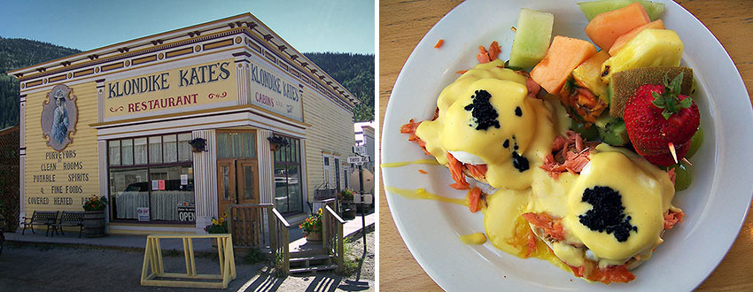
After dinner on Saturday night (again at Klondike Kate’s, where I ran into a few people I met up at the Moosehide Gathering) I decided to play a little golf at Top of the World Golf Course. A small ferry took my Norcon SUV Rental and me across the Yukon River, where I picked up the road and headed north. I pulled up at 10:35pm, but the sign on the door said they closed at 10:00. The place looked desolate, but soon the Course Marshall appeared and opened the door. I had intended on convincing this man to let me play even though they closed a good 40 minutes ago, and there was not another single soul in sight, and it was beginning to rain. He beat me to the punch, however, and offered up a set of clubs, a cart, and a scorecard. He told me just to leave it all by the door when I was done. He then locked up and drove away, leaving me with nine holes of championship golf. It began to drizzle, and the clouds dimmed the night sky as I teed off on the first hole, just before 11:00pm. It was serene and still – so much so that I could hear my ball drop on the fairway 150 yards away. Amazing. I shared the fourth green with a beautiful brown coyote that seemed to grin at my expense as he watched me three-putt, before he padded off to attend to more important business. I finished my game around 12:30 in the morning, and then drove back to the ferry, crossing back into Dawson around 1:00, and back in time 100 years.
The next morning found me talking with my camp neighbors from Montana. They were a retired couple driving through Dawson on the way to Alaska via The Top of the World Highway, sleeping in the back of their SUV as they went. Mr. Montana talked to me about their canoe and remarked on the impressive quality of my REI tent, as Mrs. Montana offered to fix me a Spam sandwich. Later I took a walking tour of the city, and made a brief stop at Midnight Dome – a rocky plateau above the town, offering an amazing view of Dawson. I drove up the crooked roads past the crooked cemeteries and arrived to find not only a picture perfect view of the town, but also a man dressed in a blue jumpsuit complete with helmet and goggles who was unfolding what I thought was a parachute. After slyly inquiring if he was BASE-jumping, he pointed out that he was unfolding a parasail, not a parachute, as if it was intuitively obvious to even the most casual observer. My mistake. I asked him a lot of annoying questions about his sport as he tugged and adjusted the many lines connecting him to his sail. We chatted a bit until a good gust came along, picked him up and took him away, sailing high above the dirt streets and ramshackle buildings of Dawson. I watched him until he disappeared into the landscape, as I was about to do myself, but with both feet, or more aptly, four wheels on the ground.
The Dempster
It was 4:00, and far too late to begin an eight-hour journey into the unknown. But there I was anyway, 30 miles out of Dawson, and sitting parked in front of the sign indicating the beginning of the 450 mile-long gravel road known as The Dempster Highway. Completed in 1979 after 20 years of construction, the Dempster is named after Sergeant Jack Dempster of the North West Mounted Police. He became a prominent Canadian historical figure in the winter of 1911 when he led the search for the “Lost Patrol.” The Dempster follows the old trapper trail that was navigated on sled behind a team of dogs. In turn, these trails followed the trails established by the Inuvit and Gwich’in people, who still account for most of the population in this part of the world.
With my video camera atop its tripod, which I had secured firmly to the passenger seat with bungee cord, I shifted into drive. Soon I found myself driving on gravel and entering a forest of Black Spruce. My Sirius satellite radio was picking up some great classic rock, and I pushed on for about an hour or so, until I reached Tombstone Recreation Area, where the road begins to ascend into the Ogilvie Mountain Range. I stopped at the Interpretive Center and talked with the Ranger for a while. He, like almost everyone I had met so far, wanted to know about the camera I was carrying – a Panasonic DVX, not a small point-and-shoot kind that most travelers would carry. Mine was much larger, with a large lens and shotgun microphone attached to its side. I had been asked if I was with the news, or if I was filming for the CBC, or sometimes it was just, “Hey, that’s a nice fuckin’ camera, ay?”
A quick note – almost all Canadians I’ve met swear. Young and old, men and woman – their acerbic tongues did not discriminate. But Canadians are such a warm, friendly, unassuming bunch, with such a pleasant, lilting accent that the words just roll out in a very casual, inoffensive way. I loved it.
The young kid working at the Tombstone Interpretive Center was no different:
“Gee, that’s a nice fuckin’ camera. What’cha doin’ with it?”
“I’m just making a little film of my trip up the Dempster.”
“Shit, how far ya’ goin’, ay?”
“All the way to the Arctic Ocean”
“Oh shit, that’s fuckin’ wicked, ay?”
“Yes, it is fucking wicked. Fucking wicked indeed.”
“Well ya heard aboot the five people got killed on the highway up by the border there, ay?”
Yes, I had heard. Nearly everyone I’ve met has told me about it. Comforting. We chatted for a while about marmots, and then I shot some video by the creek. Then I was back on the road.
The highway is made entirely of gravel, built straight up as high as 20 feet in some places. It curves and dips, it is uneven and filled with potholes, there is often no shoulder, and there are no guardrails of any kind, even when ascending though mountainous passages snaking over precipitous cliffs. The road is covered with shale in many places, a sharp, jagged stone that can easily shred a tire in an instant. And, there are no services until the halfway point at Eagle Plains, at mile 220.
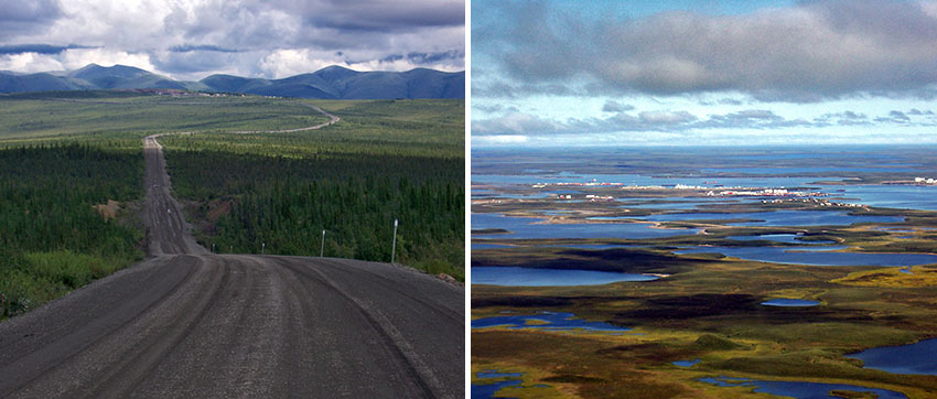
I began the ascent into the Ogilvie Mountains, the first range I would pass through on the journey. I drove through some stunning vistas, and stopped to get some footage. As I turned a bend in the road, I got my first breathtaking eyeful of the sweeping Sub-Arctic tundra. As far as I could see in any direction – easily hundreds of miles – the landscape of rolling hills was covered in a hirsute of small, green, mossy bushes. Bright blue bodies of water – hundreds of them, in all shapes and sizes, were the only things that interrupted the greenery. Not a tree in sight. And, other than the gravel on which I rode, there was no hint of human presence, past or present. Spectacular. I pushed on through, vista after endless vista, all washed in a palate of greens and blues – the land, the lakes, the sky. Unless you count the white clouds, which I noticed were getting a bit darker.
The road rolled on, through stunning mountain passes, through impossibly narrow canyons, and through endless, lake-filled valleys. The skies, which were at first a deep blue filled with perfect white clouds, were now darkening to an ominous gray. Within minutes it began to rain. I traveled on through the bottom of a narrow valley, where a few trees were hiding. My car, already quite dusty from the streets of Dawson, was now covered in a thick layer of dirt. I couldn’t see out the back window at all, for all of the grime. It rained heavily for a few minutes, but overall it was a fairly short storm. Soon the sun reappeared and seemed to cast a whole new light on the scenery. In fact, the landscape seemed to transform itself with every curve of the road. With varying light and elevation it was a constantly changing vista.
I continued on through the valley floor when my satellite radio finally quit on me. There was no more signal to be found. I switched to my mp3 player. I drove past Engineer Creek Campground without stopping at the Interpretive Center. I didn’t need to hear, yet again, about the tourists who ran off the road. As I turned a bend in the road in a particularly heavily wooded area I came car-to-face with my first “Yukon Blonde” – a grizzly bear. Not 50 feet in front of me stood the enormous creature. I came to a stop and he turned to look at me. His eyes met mine straight through my chipped-up windshield, and we regarded each other for a brief, tense moment. It was just the two of us, and he must have been three times my size. After careful deliberation on his part (I assume choosing whether or not to eat me), he padded down the side of the road and was lost to the thicket of trees.
It was getting late, about 10:30, but still light despite the cloud cover. I finally ascended out the valley and into another pass when I hit a fog bank that reduced my visibility to less than 10 feet. I was crawling along down the center of the road, where I was doing most of my driving anyway, as you pass almost no one, and when you do, you usually see them coming from miles away. I was hoping that should I meet anyone coming from the other direction, they’d be going just as slow as I was in this thick, white haze.
Then, in an instant, with not so much as an, “I’ll fuckin’ catch’ya later, ay?” the fog was gone. But, the “low fuel” light had turned on. I was sure that my initial estimates were right, and I had plenty of fuel to get to Eagle Plains. I was doing a quick re-figuring of my kilometers-to-miles calculations, when the next fog bank hit just as hard as the first. I thought I saw a sign for Eagle Plains, but how far? I was at the top of a summit with no end in sight. Then the fog broke. And then it was back. It carried on like that until almost midnight, as did the car, seemingly riding on fumes, when in the middle of the darkest fog bank I rolled up on the Eagle Plains Lodge.
The inaptly named lodge (located on an eagle-less summit) offered food, gas, tire repair, a few motel rooms, a campground, and limited airstrip facilities. I had initially intended on camping. However, it was very cold and windy, the fog remained thick as my grandmother’s homemade pea soup, and I was quite exhausted. If there was a room available, it had my name on it.
I entered the lodge, passing a stuffed caribou on my way to the office. Blood-red carpets trailed off down long, narrow hallways. The walls were covered with “death” pictures of the three frozen men from the Lost Party of 1911. I saw not another living human in the place. I suddenly had the eerie feeling I had just walked into a forgotten “ghost-lodge” that rises out of the fog, beckoning travelers to their doom. The office was closed, but the sign said, “See bartender for rooms.”
The Eagle Plains Lodge
I found my way into the lounge, across the lobby of the lodge. A dozen people, all clearly locals, were drinking and talking, and everyone in the joint came to a sudden and abrupt stop when I walked in. All eyes shifted to me, the big pale guy with the camera walking into the lounge at the stroke of midnight in the middle of the middle of nowhere. I nodded a few greetings and then turned to the bartender, a girl barely old enough to drink herself. Before I could ask for a room, she announced last call, and everyone in the joint ordered three more beers apiece. I ordered a shot of Canadian Club with a Molson’s Canadian back, to celebrate my arrival.
I exchanged my signature on a credit card receipt for a room key, and was working on my Molson when I noticed a large man wave me over to his table. I walked over and he pushed a chair out for me with his leg, motioning for me to join him and his two buddies. They seemed to be a few Molson’s to the wind themselves. Turns out they were three Gwich’in men from the tiny town of Fort McPherson who had been fishing all day.
“The fishin’s been fuckin’ great, ay? Caught us some trout and grayling almost twelve inches long. Been drivin’ all up and down the road stoppin’ at every creek and river. You fish, ay?”
“Well, I’m not much of a fisherman…” I admitted.
“Shit, cousin, you gotta get down to Klondike Corner and drop a line!”
So there I was sitting with Kenny, Perry, and Keith, talking about fishing and the grizzly I saw and the fog. A deep-blue twilight streaming in through the mist filled the windows of the lodge. Twenty minutes later, with my beer quite finished, I shook the meaty hands of my new cousins and called it a night.
I awoke early the next morning and looked out the window. The fog was thicker than the night before. There would be no way to drive in this. I spent a little time in the room, and then went for breakfast in the dining room. By the time I was done eating, the fog had lifted and I was ready to go. However, there was a buzz of activity in front of the lodge, and there would be another hour of conversations with friendly strangers. A motorcyclist asked me about the road conditions to the south. A middle-aged couple asked if I had seen any grizzlies. A young family man advised me on some driving tips along the road. It seems as if everyone had something to say about something. And, of course, everyone reminded me of the five who died last week, just up the road a bit from here, near the border crossing into the Northwest Territory. I was warned that the road gets really bad just north of the lodge, made worse by the rain and fog, and I should be, “Extra fuckin’ careful, ay?”
The Signpost at the Top of the World
It was now 11:00 and they skies were iffy, at best. I filled up the tank and headed out. The next dozen miles or so weren’t too bad, with some foggy patches here and there. And then I reached another milestone of the trip – the Arctic Circle. I pulled off the road to step out and take a few pictures and video of the signpost. I stood there alone in utter silence, admiring the very best that nature has to offer. I must have stood there for thirty minutes, uninterrupted, in silent reverence.
An ominous boom of thunder broke the glorious silence. I instantly recalled walking into Chatres Cathedral in the French countryside, outside of Paris, many years ago. As I entered the doorway of this magnificent thousand-year-old cathedral, a thunderclap roared in an otherwise sunny sky. It was a powerful and profound moment of my life. And here I was, standing at the Arctic Circle, a doorway to one of nature’s own ancient cathedrals, and a loud thunderclap again punctuated another overwhelming and poetic moment.
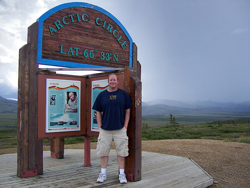
Disturbingly dark clouds had now moved in behind me and quickly covered the sky. The thunder became louder and more frequent and louder yet, and seemed to echo against the mountains that rose from the tundra miles away. Rain began to drop, lightly at first, then steadily harder and harder. It was time to move on. Back on the road things quickly got a bit dodgy. I had hit that much-talked-about “rough” spot on the road. It was rutted and pockmarked and narrow. The rain and thunder picked up in intensity, and so did I. My hands gripped the wheel and I struggled to see, even with wipers sloshing at full tilt. The numerous potholes quickly filled with water and blended in with the gravel, making them difficult to distinguish until I was on top of them. The car bucked and bounced, splashing up great sprays of water. Bolts of lightning flashed in front of me, lighting up the ethereal landscape. I was in my element. I love the rain and to be caught in a storm of this magnitude in this part of the world was more than I could have asked for.
Then it really started to rain. Blankets of water seemed to move sideways, buffeting my car. The road literally turned to a river of slick mud, and now driving was truly impossible. I pulled as far over onto the soft shoulder as practical, and sat in total amazement at the force of the rain. The wipers were useless, and my car was awash in thick mud. I rolled the video camera, sat back and enjoyed nature’s powerful display.
Ten minutes passed and the rain had diminished enough that I felt it was okay to drive, and I had a lot of wet ground to cover. The road was still slick, and the potholes remained a constant obstacle, but my four-wheel drive was up to the task. While the weather slowly improved, the road itself worsened. The gravel was looser and made worse by the rain, and although I found myself sliding around a bit, I continued on. The skies were finally starting to clear in front of me, and a quick look behind me confirmed the storm was rolling away, a goliath roaming the tundra. By the time I reached the border crossing, the skies were again bright and blue.
At the summit that serves as the dividing line between the Yukon and the Northwest Territory, I came across three travelers from France. They were making the same journey, from Whitehorse to Inuvik. However, they were doing it by bicycle. It made my three-day, camping-by-bike trips to Catalina Island almost seem embarrassing. They had been en route for five weeks and seemed in bright spirits. We talked for a long while in the cold, gusty wind atop this summit before taking some pictures and exchanging Merci Beaucoups and Bon Voyages and Au Reviors.
For days it had seemed as if I had been climbing the side of the very Earth herself, pulling my self ever upward over uncertain terrain. Now, as I descended the final summit on the last bit of unstable road, it felt as though I had made it over the final precipice, heaving myself up to a safe and secure plateau.
Not long after entering the Northwest Territory I rolled onto the ferry for the short trip across the Peel River. In the winter, the river freezes and you can simply drive across it on an ice bridge. But, in the summer, a two-car ferry stands at the ready for the random traveler or supply truck. On the other side of the Peel I made a quick stop in Fort McPherson for gas and water, then Northward once again. The road, while still gravel, was wider and flatter and smoother, and I could reach speeds of 90 kilometers per hour (55 mph). Soon I boarded another ferry, again as the only passenger, and crossed the McKenzie River, second in length and volume in North America, to be outdone only by the mighty Mississippi. It drains a full one-fifth of all of Canada. Now, it would be only an hour or so on the road until I reached Inuvik.
Inuvik
I was zipping along the tundra heading straight for the Beaufort Delta. The McKenzie river begins far to the Southeast at The Great Slave Lake near Yellowknife, the capital of the Northwest Territory. It heads north from there, eventually draining into the Arctic Ocean at the Beaufort Sea, creating one of the world’s largest, natural deltas. As a result, the tree line extends further north here than anywhere else on the planet at this latitude. The Spruce, however, are short, spindly, and sparse, and only grow near the water. And, there are no mountains. The land stretches on and on with nothing to interrupt the view for hundreds of miles in all directions.
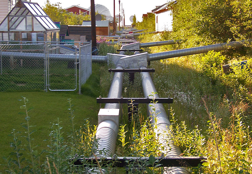
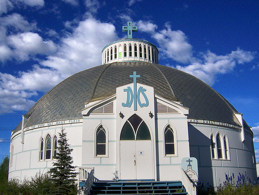
Soon, I passed by the sign to Jak Park, where I would be camping. It was about 10:00pm and the sun was higher in the sky than I had ever seen at this hour. I bypassed the park, opting instead to head straight into Inuvik to pick up some supplies. A few minutes later I was in what passed for their downtown. Inuvik had none of the charm of Dawson, but a unique atmosphere all it’s own. The town was built by the government in the 1950’s to replace the native village of Aklavik, some 60 miles to the west, which was sinking into the permafrost. However, the locals tell a different story of how this was just an excuse used to create a hub for the emerging oil business in the region. To this day, Inuvik serves at the center of commerce for the Canadian Western Arctic, including oil, transportation, communication, and the environment. However, it is still populated mostly by the Inuit and Gwich’in. All of the buildings sit atop log or steel pilings, 4-5 feet off the ground, so the heat transfer doesn’t melt the permafrost beneath. Long metal tubes known as Utilidors run above ground between all buildings. The permafrost also prevents pipes from being buried underground, so these Utilidors house the lines for water and waste. Most buildings look like government-built structures of the 50’s, save the Catholic Church in the center of town built to resemble an igloo.
The town, even at this hour, was abuzz with activity – mostly teens and younger children on bikes or skateboards speeding through the streets. And there were taxi’s running to and fro – a non-stop stream of them it seemed – a peculiar sight in such a small town. I stopped in Max’s News Stand, the local convenience store, for a few items and noticed the headline on the local paper – “Grizzly Scare in Delta.” The second heading on the page read “Five Die in Dempster Crash.”
I pulled into beautiful Jak Park campground, situated on a bluff overlooking part of the delta, and it quickly became obvious that I was the only one there. The grounds were empty. I checked in with the attendant, who warned about the bears. It seemed that Inuvik was a bit overrun with them this summer. Seven of them had been hanging around the park, and a few had been heading into town. One even pushed its way into a house by the lake around two in the morning the previous week, giving the owner’s out-of-town visitors quite a start. Determined bears, swarms of steroid-using mosquitoes, and the bright midnight sun conspired together, prompting me to seek safety in the shelter of my SUV – I opted to sleep in the back instead of my tent.
Stay tuned for 37 Above 60, Part II

